When the pavement ends and the cell signal disappears, your phone stops being a navigation tool and becomes a paperweight. A dedicated off road GPS keeps working deep in the backcountry where there are no towers and no marked roads, pulling your position straight from satellites and showing you trails, forest service roads and topographic terrain that a standard car navigator never loads. For 4×4 wheeling, overlanding, dual-sport riding and remote camping, the right unit is the difference between a confident route and a long walk out.
We put the most popular trail-focused units through real dirt, mud, dust and glove-handed use to see which ones actually hold a fix under tree cover, survive a tumble off the dash, and load the off-pavement maps you need. Below are the seven best GPS units for off road trails in 2026, ranked best first, with honest notes on where each one falls short.
| Photo | Product | Score | Buy |
|---|---|---|---|
 |
Garmin Tread Overland Edition Best Overall 5.5-inch glove-friendly touchscreen, preloaded topo and public land maps, Group Ride Radio compatible |
9.5 |
ⓘ We may earn a commission from qualifying purchases made through links on this page, at no extra cost to you.
|
 |
Garmin GPSMAP 67 Best Handheld 3-inch sunlight-readable display, multi-band GNSS, up to 180 hours battery in expedition mode |
9.3 | 🛒 Check Price |
 |
Garmin Montana 700i Best Touchscreen 5-inch glove-friendly touchscreen, inReach satellite SOS and messaging, multi-GNSS |
9.1 | 🛒 Check Price |
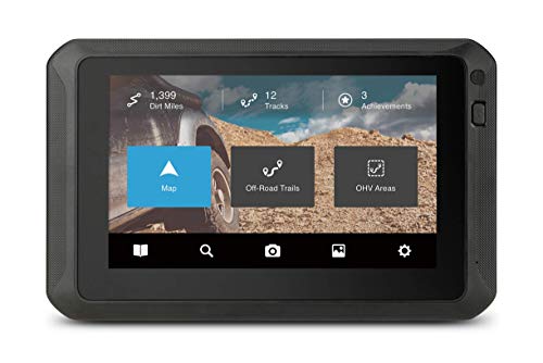 |
Magellan TRX7 CS Pro Best for 4×4 Trails 7-inch rugged trail tablet, preloaded US trail database, IP67 dust and water rating |
8.9 | 🛒 Check Price |
 |
Garmin eTrex 22x Best Value 2.2-inch sunlight-readable screen, 8GB internal memory, up to 25 hours on two AA batteries |
8.7 | 🛒 Check Price |
|
Garmin Overlander Best All-Road Hybrid 7-inch all-terrain touchscreen, on-road and off-road routing, topo and public land maps |
8.5 | 🛒 Check Price |
 |
Garmin GPSMAP 65s Best Battery Life 2.6-inch display, multi-band GNSS, up to 16 hours rechargeable plus barometric altimeter |
8.3 | 🛒 Check Price |
1. Garmin Tread Overland Edition: Best Overall
The Garmin Tread Overland Edition is the unit we reach for first because it was designed from the ground up for going off pavement rather than adapted from a road navigator. It ships with topographic mapping, public land boundaries and a deep library of unpaved forest service and BLM roads, so you’re routing on trails the moment you power it on. The pitch and roll inclinometer, altimeter and barometer turn the screen into a genuine trail dashboard, and the 5.5-inch display stays legible through dust haze and harsh midday glare where lesser screens wash out.
Its honest weakness is size and ecosystem reliance. The Tread is a chunky device with a substantial mount, and on a tight motorcycle bar or a cluttered 4×4 dash it can feel like it’s fighting for space. A few of the more social features, like advanced group tracking, work best when tethered to the Tread phone app, so you aren’t getting the absolute most out of it as a fully standalone box. For dedicated overlanders, though, the trade is worth it and this is the most capable trail navigator we researched.
- Preloaded topographic maps with public land boundaries and 4×4 forest roads
- Pitch and roll inclinometer plus altimeter and barometer for trail awareness
- Bright sunlight-readable 5.5-inch display rated for vibration and dust
Pros: Purpose-built for overlanding with terrain data baked in, not bolted on; Large screen stays readable in direct desert sun and reads pitch and roll live; Pairs with the Tread app and Group Ride for convoy tracking
Cons: Bulky mount takes up real estate on a small dash or handlebar; Some features lean on a paired phone for full functionality
2. Garmin GPSMAP 67: Best Handheld
When the trail turns into a footpath or you need a navigator that works whether you’re in the cab or on your boots, the Garmin GPSMAP 67 is the handheld to beat. Its multi-band, multi-constellation receiver is the standout, locking onto satellites and holding position under dense canopy and in deep canyons where single-band units drift or drop out. Pair that with up to 180 hours of battery in expedition mode and you have a unit that keeps navigating long after a vehicle-powered screen would have gone dark, which matters on multi-day remote trips.
The compromises are ergonomic. At 3 inches the screen is small for glance-and-go driving, so it shines more as a primary handheld and trip recorder than as a big dash display. The button-and-joystick control scheme is reliable in the rain and with gloves, but it feels old-fashioned and slow compared to swiping a touchscreen. If you value raw accuracy, ruggedness and battery life over screen size, nothing here serves the true backcountry better.
- Multi-band multi-GNSS reception holds a fix under heavy tree canopy
- Marathon battery life rated up to 180 hours in expedition mode
- TopoActive maps with routable trails and barometric altimeter built in
Pros: Outstanding fix accuracy and canopy performance from multi-band GNSS; Battery life crushes anything dash-powered when you’re off-grid for days; Rugged IPX7 body survives drops, rain and rough handling on foot or vehicle
Cons: Small 3-inch screen is harder to read at a glance while driving; Button and joystick interface feels dated next to a touchscreen
3. Garmin Montana 700i: Best Touchscreen
The Garmin Montana 700i is the best of both worlds for people who want a real touchscreen on the trail without giving up handheld portability. The 5-inch glove-friendly display is large enough to act as a dash navigator yet the unit is fully self-contained with its own battery, so it works in the vehicle or in your pack. The headline feature is the built-in inReach satellite communicator, which lets you send two-way messages and trigger an SOS from places with zero cell signal, turning the navigator into a serious safety device for solo or remote runs.
Its drawbacks come down to bulk and subscription. This is a chunky, heavy handheld, and after a long hike you’ll feel it in your pack compared to a slimmer unit like the GPSMAP. The inReach features that make it special also require an active satellite plan, so part of what you’re paying for only works while you keep that service live. For drivers who want one device that navigates, communicates and survives anything, the Montana 700i earns its spot.
- Large 5-inch glove-compatible touchscreen built for vehicle and trail use
- Built-in inReach satellite two-way messaging and SOS off the grid
- TopoActive maps with routable trails plus barometric altimeter and compass
Pros: Big bright touchscreen bridges handheld and dash-mounted use cases; Integrated inReach SOS is a genuine safety net beyond cell coverage; Rugged MIL-STD chassis handles vibration, dust and water
Cons: Heavy and thick for a handheld you carry on foot; Satellite messaging needs an active subscription to use
4. Magellan TRX7 CS Pro: Best for 4×4 Trails
For dedicated 4×4 and side-by-side wheeling, the Magellan TRX7 CS Pro leans hard into one thing and does it better than anyone: trails. It arrives with an enormous preloaded database of recorded off-road routes across the United States, and the active TRX community keeps adding tracks you can download, follow and rate. The 7-inch rugged display is genuinely sized for a vehicle dash, making it easy to read the next turn while bouncing through ruts, and the IP67 body laughs off the dust and water that comes with serious trail days.
The honest catch is that this is a vehicle device through and through. At 7 inches it’s far too large and power-hungry to carry on foot, so it doesn’t pull double duty as a handheld the way a Montana or GPSMAP does. The software is also a step behind Garmin in responsiveness and polish, and you’ll notice occasional lag when panning maps. If your world is four wheels on dirt and you want the deepest trail library, though, the TRX7 is built exactly for you.
- Massive preloaded database of recorded off-road trails across the US
- Large 7-inch rugged display made for in-vehicle 4×4 navigation
- Record, share and follow tracks with the TRX trail community
Pros: Best-in-class library of crowd-recorded 4×4 trails out of the box; Big 7-inch screen is easy to read while wheeling rough terrain; Rugged IP67 build shrugs off dust storms and water crossings
Cons: Bulky form factor really only suits a vehicle dash, not foot use; Software interface feels slower and less polished than Garmin's
5. Garmin eTrex 22x: Best Value
The Garmin eTrex 22x proves you don’t need the biggest unit to navigate confidently off the grid. Its trump card is power: it runs on two standard AA batteries, so when it dies on day three you drop in a fresh pair from your pack instead of hunting for a charge port. The dual GPS and GLONASS receiver holds a respectable fix under tree cover, the 8GB of memory leaves plenty of room for topo regions, and the whole thing is light enough to forget in a jacket pocket until you need it.
You give up screen real estate to get there. At 2.2 inches the display is small and the resolution is modest, so reading a complex map at a glance while driving is harder than on a larger unit. The button interface, while glove-friendly and waterproof, is slower to operate than a touchscreen. For riders, hikers and overlanders who want dependable, field-serviceable navigation without fuss, the eTrex 22x delivers a lot of capability in a small, sensible package.
- Runs on common AA batteries you can swap anywhere on the trail
- Supports GPS and GLONASS for solid fixes in tough cover
- Preloaded TopoActive base map with room for additional regions
Pros: Excellent battery flexibility with field-swappable AA cells; Compact, light and genuinely pocketable for hikers and riders; Reliable, no-nonsense navigation that just works
Cons: Small 2.2-inch screen and modest resolution; Button navigation is slower than a touchscreen
6. Garmin Overlander: Best All-Road Hybrid
The Garmin Overlander is the unit for people whose trip is half interstate and half dirt, because it’s one of the few devices that routes confidently on pavement and then switches to genuine off-road navigation when you leave it. The 7-inch touchscreen carries topographic maps, satellite imagery and public land boundaries, and the built-in pitch and roll gauges, altitude readout and campground directory make it a true overlanding companion rather than a repurposed car GPS. For a road trip that turns into a backcountry camp, it covers the whole journey on one screen.
The compromise is depth on the dirt. Its off-road trail database isn’t as rich as a trail-first device like the Magellan TRX7 or the Tread, so for hardcore wheeling on obscure routes you may find fewer recorded tracks to follow. The large screen and mount also demand a fair bit of dash space. But as a do-everything navigator that erases the line between highway and trail, the Overlander is hard to beat.
- Switches between on-road and off-road routing in one device
- Preloaded topo, satellite imagery and public land boundary maps
- Pitch and roll gauges plus campground and dump station directory
Pros: Smoothly handles both highway driving and trail navigation; Large 7-inch screen with useful overland gauges and trip data; Helpful directory of campgrounds and overland services built in
Cons: Off-road trail database is thinner than a dedicated trail unit; Large screen and mount need a roomy dash
7. Garmin GPSMAP 65s: Best Battery Life
The Garmin GPSMAP 65s is the value entry into Garmin’s multi-band handheld line, and it brings the feature that matters most off road: accuracy. Its multi-band GNSS receiver tracks more satellites on more frequencies, so it holds position in tight canyons and under thick forest where cheaper units wander. You also get the full sensor suite, a barometric altimeter and electronic compass, plus routable TopoActive maps, all wrapped in a rugged IPX7 waterproof shell that takes drops and downpours in stride.
It sits below the 67 for two reasons. The 2.6-inch screen is smaller and a touch lower resolution than the flagship, and its rechargeable battery, while solid, doesn’t reach the marathon runtime of either the GPSMAP 67 or the AA-swappable eTrex models. For most weekend trail runs that’s plenty, and you’re getting flagship-grade reception in a more compact, more affordable body. If precise positioning in hard terrain is your priority, the 65s punches above its class.
- Multi-band GNSS support for accurate fixes in canyons and forest
- Barometric altimeter, compass and TopoActive routable maps
- Rugged IPX7 waterproof handheld body with sunlight-readable screen
Pros: Strong multi-band accuracy in difficult terrain; Trustworthy waterproof, drop-resistant construction; Routable topo maps and full sensor suite for the trail
Cons: Smaller screen than the flagship GPSMAP 67; Shorter rechargeable runtime than AA-based eTrex models
Frequently Asked Questions
Do I really need a dedicated GPS for off road trails, or is my phone enough?
Your phone works fine until you lose signal, and on real off road trails you’ll lose signal constantly. A dedicated GPS pulls your position directly from satellites and stores topographic and trail maps locally, so it keeps navigating in dead zones, deep canyons and dense forest where a phone goes blank. Trail GPS units are also built to survive dust, water, vibration and drops that would kill a phone, and they run far longer on battery. You can preload offline maps on a phone as a backup, but for primary backcountry navigation a rugged dedicated unit is far more reliable.
What is the difference between a handheld GPS and a dash-mounted trail GPS?
A handheld like the Garmin GPSMAP 67 or eTrex 22x is compact, battery-powered and goes wherever you do, in the vehicle or on foot, which matters if your trip includes hiking, scouting or a long walk back. A dash unit like the Magellan TRX7 or Garmin Tread has a much larger screen that’s easier to read while driving rough terrain and usually draws power from the vehicle. Handhelds win on portability and battery flexibility, dash units win on screen size and at-a-glance driving use. Hybrids like the Garmin Montana 700i try to give you both.
What features matter most in a GPS for off road use?
Prioritize four things. First, mapping: you want preloaded topographic maps with trails, forest service roads and public land boundaries, not just highways. Second, reception: multi-band, multi-GNSS receivers hold a fix under canopy and in canyons where single-band units drift. Third, durability: look for IPX7 or IP67 ratings so dust and water crossings don’t end your trip. Fourth, battery and power: long runtime or field-swappable AA cells keep you navigating on multi-day trips. Bonus features like an inclinometer, altimeter and satellite SOS add real value for serious overlanding.
Can these GPS units share trails and tracks with other riders?
Yes, and it’s one of the best reasons to buy a trail-focused unit. The Magellan TRX7 has an active community trail database where users record, upload and download thousands of off-road routes you can follow turn by turn. Garmin units let you record your own tracks and share them through the Tread or Explore apps, and convoy-oriented models like the Tread support Group Ride tracking so you can see other vehicles in your party on the map. Recording your own tracks also means you can always retrace your exact route back out if the trail gets confusing.
Will an off road GPS work where there’s no cell service at all?
Absolutely, and that’s exactly what they’re built for. These devices receive positioning signals directly from GPS, GLONASS, Galileo and other satellite constellations, which have nothing to do with cell towers. As long as the maps are loaded onto the device beforehand, the unit shows your precise location and routes you on trails with zero cell coverage. If you want communication on top of navigation, a model like the Garmin Montana 700i adds built-in inReach satellite messaging and SOS so you can reach help from places with no signal whatsoever.
Our Verdict
For the best all-around off road trail navigation, the Garmin Tread Overland Edition is our top pick, with terrain mapping, public land data and a glove-friendly screen all purpose-built for going past the pavement. If you want a rugged unit that works just as well in your hand on a multi-day backcountry trip, the Garmin GPSMAP 67 is our runner up, delivering the best reception and battery life of the group. Match the unit to how you travel, dash size, handheld portability or community trail data, and any pick on this list will keep you confidently on course where your phone gives up.